Thailand
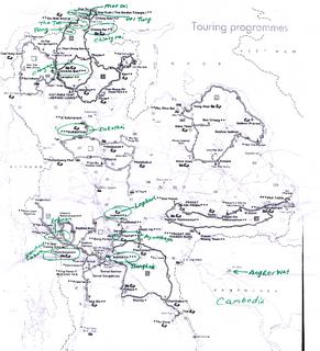
I attached a map of Thailand and Cambodia.You can double click on the picture for better view. If you have problem viewing the picture, please double clich on it.
I spent a week backpacked following the route starting from Phuket by air, and spent few hours taking tuktuk (a motor transport) around the island, and in the evening, I changed to coach bus taking about 12 hours passing Hua Hin heading north to Bangkok. At Bangkok, I spent a day visiting Wat Sai floating market of river Chao Phraya and the city.
The next day, I took a train going north to the historical site Ayutthaya. After visiting several temples, I got a bus to visit the Temple of Buddha's footprint. After the visit, I changed to train going North again to Sukhothai province, Lop Buri, I could remember vividly that it was Chinese New Year, because I could hear fire crackers sound waking me up early in the morning. I spent a day visiting historical temples and took a coach going North to Chiangmai.
Chiangmai's weather was coolly. The famous spots are Wat Phra Singh , Doi Suthep and the market place. After Chiangmai. I headed North again, I took a bus to Fang, changed to a mini-bus to Tha Thon pier for raft to Chiang Rai, and traveling down hundred km by boat of Kok river. This gives me a chance to soak up a rich diversity of typical northern landscape which I never get on the speeding bus.
Chiang Rai is a place adjacent to Laos and Myanmar. A famous spot to visit is Doi Tung. I reached there was evening time. The weather changed to icy. On the same day. I took a night coach back to Bangkok.
This time I headed West by train to Kanchanaburi province. The notorious spots are River Kwai, the film "the bridge over River Kwai" made river Kwai a famous spot but really looks quite ordinary. The material for the bridge were brought from Java by the imperial Japanese army. The Death Railway to Myanmar is also site of wartime reminder. It is estimated that 16,000 POWs died while building the Death Railway to Myanmar of which the bridge is only a small part. The strategic objective of the railway was to secure an alternative supply route for the Japanese conquest of Myanmar and other Asian countries to the west. The Japanese army forced the POW to complete the 415km railway suppose to build in five years to only 16 months. The labors, POW , many from Thailand, Myanmar, Malaysia and Indonesia estimated around 90,000 to 100,000 laborers died in the area. Other war reminders are The war cemetery and The Jeath war Museum. Erawan National park is another main sight notorious for its seven-tier waterfall. It was a day at Kanchanaburi and then back to Bangkok and headed home.
Puket

 Phuket is Thailand largest island, and remains the wealthiest province in Thailand. Basically, its main business activities is
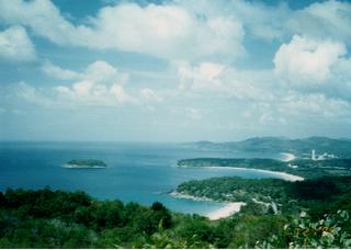
Tourism. It offers a huge range of water sports and magnificent diving facilities to make the most of the clear and sparkling seas. The famous spots are Ao Patong which is 15km from Phuket town, , the most developed and expensive, with a nightlife verging on the seedy. The picture shows three tourist spots Ao Karon beach, is slightly nicer, and adjacent Kata Yai (big kata Bay) beach and Kata Noi beach (small kata bay) the kata is the smallest and least spoilt of the trio. If you are really looking for peace and quiet you should turn instead to some of the beaches on the far northwest coast, such as Hat Nai Thon or Hat Nai Yang. Besides beach going, Laem Phrom thep is a popular place to view sunset. You can also go up Khoo Rang Phuket hill to have a bird-eye view of the City.
Ayutthaya
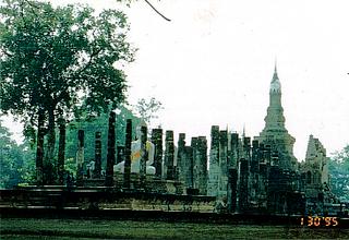
Ayutthaya, 80km north from Bangkok was founded by U Thong in1351, and rose rapidly by expanding trade route with China and India. It stepped into the political vacuum left by the decline of the Khmer empire at Angkor (In Cambodia) and the first Kingdom at Sukhothai. Ayutthaya by the mid-fifteenth century controlled an empire covering most of the area of modern-day Thailand. In 1767, this 400 years long prosperous dynasty was captured by the Burmese, and many wats (temples) were in ruin. And now it resembles a graveyard for temples, grand, brooding red-brick ruins rise out of the fields, satisfyingly evoking the city's bygone grandeur.
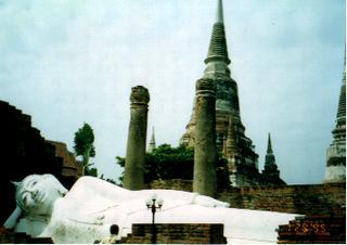 This picture is Wat Yai Chai Mongkol. The reclining Buddha represents the Buddha's dying moment when he attained Parlnibbana or ultimate nirvana. The Wat was established by King Ramathibodi in 1357 as a meditation site for monks returning from study in Sri Lanka. You can also visit Wat Phanan Cheong (the oldest temple in town) and Wat Phra Si Sanphet (the largest in its time).
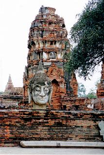 This picture is Wat Phra Mahathat . The name "Mahathat" indicates that the temple was built to house remain of the Buddha himself (according to royal chronicles). King Ramesuan(1388-95) was looking out of his palace one morning when ashes of the Buddha materialized out of thin air here. A gold casket containing the ashes was duly enshrined in a grand 38m high prang. You can climb what remains of the prang to get a good view of the broad grassy complex, with dozens of bricks spires tilting at impossible angles and headless Buddha scattered around like spare parts in a scrapyard
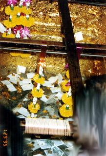 This picture is Wat Phra Phutthabat (Temple of Buddha's footprint) (You can refer the footprint from the picture), is the most important pilgrimage site in Central Thailand. I was attracted by the interesting story. The place is at 17 miles Southeast of Lop Buri along Western site of the highway.
The legend dates back to the beginning of 17 century when King Song Tham of Ayutthaya sent some monks to Sri Lanka to worship the famous Buddha's footprint of Sumunkut. To the monk's surprise, the Sri Lankans asked them why they had bothered to travel all the way going there when according to the ancient pali scriptures, the Buddha has passed through Thailand and had left his footprint in their own backyard. As soon as King Song Tham heard this he instigated a search for the footprint which was finally discovered in 1623 by a hunter name Pram Bun when a wounded deer disappeared into a hollow and emerged miraculously healed. The hunter pushed aside the bushes to discover a foot-shaded trench filled with water which immediately cured him of his terrible skin decease. A temple was built on the spot but was destroyed by the Burmese in 1765. The present buildings date from the Bangkok era. Ah! Not forget to tell you, the footprint is five feet long. Imagine how large is the Buddha body!
Sukhothai Province
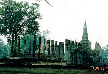
Prior to 13 century, the land now known as Thailand was divided into a collection of petty principalities. Most of which owed their allegiance to the Khmer empire and its administrative centre at Angkor in Cambodia. With the Khmer's power on the wane. Two Thai generals joined forces in1238 to oust the Khmers from the northern plains, founding the kingdom of Sukhothai( It means dawn of happiness in Pali) under the regency of one of the generals Intradit. Intradit's youngest son Ramkhamhaeng laid the foundations of a unique Thai identity by establishing Theravada (Hinayana) Buddhism as the common faith and introducing the forerunner of the modern Thai Alphabet; of several inscriptions attributed to him. Ramkhamhaeng turned Sukhothai into a vibrant spiritual and commercial centre. The border pushed as far south as to peninsula Malaya. By second half of 14 century, Sukhothai became a vassal state of the newly emerged kingdom of Ayutthaya in1438, and finally was forced to relinquish all vestiges of its independent identity. Traditionally, the Sukhothai era has always been viewed as the golden age of Thai history.
 This picture is Wat Mahathat at Lopburi. The Wat Mahathat compound, packed with the remains of scores of monuments and surrounded , like a city within a city, by a moat. This was the spiritual focus of the city, the king's temple and symbol of his power, successive regents, eager to add their own stamp, restored and expanded it so that by the time it was abandoned in the sixteenth century it numbered ten viharns and the bot dominate the present scene, their soldierly ranks of pillars which formally supported wooded roof directing the eye to the Buddha images seated at the far western end.
The principal chedi complex which houses the Buddha relic built on an east-west axis in an almost continuous line with two viharns. Its elegant centre piece follows a design termed lotus-bud chedi and is classic late Sukhothai in style. Lotus bud represent the purity of Buddha thoughts battling through the clammy swamp and bursting into flower. The chedi stands are surrounded by eight smaller towers on a square platform decorated with a procession of walking Buddha-like monks. Others famous temples are Wat Si Sawai, Wat Trapang Ngoen and Wat Sra Sri, Ramkhamhaeng monument.
Chiangmai
 Chiang Mai manages to preserve some of the atmosphere of an ancient settlement alongside its urban sophistication. The people here are more easy going, and speak more slowly than their cousins in the capital. Burmese influence is still strong-not just art and architecture, but also in the rich curries and soups serve here. There are two major temples worth visiting in Chiangmai. One is Wat Phra Singh. The Buddha came from Sri Lanka. The temple was built in 1345.
This picture is part of the temple called Doi Suthep. the mountain which rises steeply at the City's 16km western edge of Chiangmai which dominate the hillside gives a towering view over the town. Doi Suthep was established in 1383. A naga (Dragon headed serpent) staircase of 300 steps lead to the Wat at the end of the winding up the mountain. This is the North hottest shrine which takes its pre-eminence from a magic relic enshrine in its chedi and the miraculous legend of its founding.
The interesting story about this temple is the original chedi here was built by King Ku Na at the end of 14 century after the growing relic of Wat Suan Dork had self-multiplied just before being enshrined. A place had to be found for the clone, so King Ku Na put it in a traveling shrine on the back of a white elephant and waited to see where the sacred animal (the elephant) would lead. It eventually climbed Doi Suthep, trumpeted three times , turned around three times, knelt down and died, thereby indicating that this was the spot for the temple.
You can have magnificent view of whole Chiangmai at the temple's lower terrace .For going to upper terrace you have to remove your shoes.
Chiang Rai
 The northernmost tip of Thailand, stretching from the Kok River and Chiang Rai to the border. On the west it is adjacent to Myanmar, on the east to Laos. What you can see is a sanitized presentation of the golden Triangle's opium fields and colorfully dressed hill people performing artificial folkloric rituals.
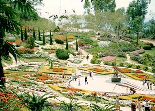
Doi Tung, is about halfway between Mae Chan and Mae Sai. At Doi Tung , you can look down over Thailand, Laos, Myanmar and China. Doi Tung means "Flag peak" from the northern Thai words. King Achutaraj of Ngon Yang ordered a giant flag to be flown from the peak to mark the spot where two chedis were constructed in 911AD. The Chedis are still there. The road up the hill is winding steep and narrow. Along the way are Shan, Akha and Musoe (Lahu) diverse ethnics' villages. Myanmar is a short trek from the peak and many travelers have cross over the border to view the large poppy fields guards by hill tribes people and KMT soldiers. At the peak 1800 m above sea level is Wat Phra That Doi Tung. Pilgrims to the Wat earn them good fortune by clanging the rows of dissonant bells around the temple compound.
This picture is The Royal Villa and Mae Fa Luang Garden,12 km up the summit then left up a side road, it was the home of the princess mother in her later years. It is an attractive site with many beautiful flowers in the garden. You can appreciate from the picture the colorful flowers blossoming in the chilling weather.
Kanchanaburi
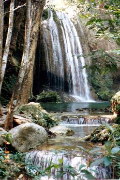
 Thism picture is Erawan National park. It is 65 km northwest of Kanchanaburi. The seven-tier waterfall, topped by a triple cascade is etched into the national imagination not just for its beauty, but also for its alleged resemblance to a three headed elephant. This elephant (Erawan in Thai) is the formal national symbol. The park covers 550 square kilometers. There are seven levels for the waterfall. Each level comprises a waterfall feeding a pool of invitingly clear water partly shaded by bamboos, rattans, lianas and other clotted vegetation. It is fairly easy to climb up to the fifth stage, but the route to the sixth and seventh level get steep and slippery. The best pool for swimming is at level two.
Cambodia
I had opportunities to visit Cambodia due to job requirement. Basically, in Phnom Penh, you can visit the Royal Palace, Wat Phra Keo,Toul Sleng Holocaust museum displays pictures and tools of how Khmer route tortured their own people during their reining in Cambodia. Once a neighborhood school, the building was seized in1975 by Pol Pot's Khmer Route and turned into a prison; during its four years of operation as an interrogation center, some 20,000 Cambodians were tortured here. Fewer than 10 prisoners survived. The bodies of those that died under torture were tossed into the school's garden and playing fields; those that survived the torture went to the extermination camp outside of town called Choeung Ek, now known as the Killing Fields. The killing field, 14km Southwest of Phnom Penh, you see urn that contains many skulls and skeletons and mass graves. I will not show you these tragic pictures of the harrowing experience of the Cambodia people. I choose Angkor Wat instead at Siem Reap to represent Cambodia.
The Cambodian (Khmer) most glamorous times was the Khmer empire between 9th to the 13th Century, Cambodia developed a complex society based first on Hinduism and then on Buddhism. After the decline of the Khmers and the ascendancy of the Siamese, Cambodia was colonized by the French in the 19th century. That is why the French still has the affection towards the Khmers. During the tenure of my job in Cambodia, The French President Chirac ever had a short stay in our Hotel. And many of our Hotel staff have great respect to the French managers. Shortly after the end of World War II, during which the Japanese had occupied Cambodia, independence became the rallying cry for all of Indochina. Cambodia became a sovereign power with a monarchy and an elected government.
In the early 70s , the destabilizing consequences of the Vietnam War led Cambodia's political factions to take up arms. A very bloody civil war ensued. Khmer Rouge, under the French-educated Pol Pot, emerging as victors. A regime of terror followed. Under a program of Mao Tse Tsung-inspired re-education centered around forced agricultural collectives, hundreds of thousands of Cambodian died through torture and execution or from malnutrition and exhaustion in the camp. You will get a better picture of these tragic times by visiting Toul Sleng Holocaust museum museum I mentioned above.
Vietnam, unified under the Hanoi government , eventually intervened, partially defeated the Khmer Rouge, and brought back Prince Sihanouk as head of the state (Now Sihanouk has abdicated from the helm, and passed to his youngest son). The United Nations was brought in as a peace-keeping force, I was working in a hotel during those period, and in1996 a government was formed through democratic elections. In 1997, Hun Sen toppled the elected government, but political pressure forced new election-monitored by the international communities-in late summer 1998. Hun Sen won a plurality amid charges of election rigging and, resort to finesse and sordid politics,through coercive tactics, formed a government. After the death of Pot Pol in mid-1998, the Khmer Rouge presence and its threat to the country's stability diminished. It remains to be seen whether foreign investment and the development of tourism will follow, whether domestic problems will be solved. As far as what I follow up after I quit the job, the living of the Cambodian people is stultifying, has hardly any ameliorating. Life still in a shamble, poverty, corruption, crime, money laundering, prostituting....I am very sympathizing the Cambodian people still limping ahead for a blissful life>.(At this time , Cambodia is experiencing booming in their economy. It successfully attracted 8 billion (US$) of foreign direct investments in 2007. The largest investor is from South Korea, followed by China. GDP growth is 9.6% in 2007 and has foreign exchange reserves of 16 billion (US$) The 42 levels of twin towers of Golden plaza at central of Phnom Penh city epitomises new era of Cambodia that rising as fast growing emerging country. Phnom Penh, Siem Reap and Sihanouk harbours are three hotspots in property development, the land and house price are soaring. Main drivers of source of income are from tourism, oilfield,natural gas, textile and agriculture. Update at May 1 2008)
Angkor Wat
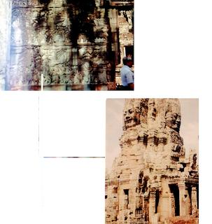
If Angkor had been discovered before the late 19th century, it certainly would have been classified as one of the seven wonders of the world. The Khmer empire reached the zenith of its power, influence, and creativity from the 9th to 13th centuries, and Angkor, the seat of the Khmer kings, was one of the largest capitals in Southeast Asia. In all there are some 300 monuments scattered in all directions through the surrounding jungle. Besides Angkor Wat, there are Angkor Thom, Ta Prohm, Banteay Srei. I am giving details of Angkor Wat.
In the typical architectural art of the Khmers, the plan of Angkor Wat is simple and audacious. The five towers are the central element of the complex, forming a lotus bud ( the emblem of the Cambodia flag). Angkor Wat was founded at the beginning of the 12th century and is the best preserved of the Khmer temples. It was erected by King SuryavarmanII (reigned 1112-52) and dedicated to the Hindu god Vishnu. Like all the major monuments at Angkor, the buildings form a complex representing the Hindu (and Buddhist) Universe. The central shrines symbolize Mt. Meru, while the gates and cloisters depict the successive outer reaches of cosmic reality. Moats represent the seven oceans that surround Mt. Meru.
Angkor Wat is reached by an impressive causeway, an avenue lined with balustrades in the form of serpents. The complex itself rises in three concentric enclosures and you must wander around the terraces marveling at the Hindu deities and Buddha images, many of which lost their heads to looters. The other amazing collections of the images is sculpted on the 1 km long open colonnaded gallery. This collection tells the Hindu epics and Suryavarman's earthly deeds, both of which are celebrated by dancing apsaras.
Architecture and the fine relief symbolize the richness, power, and prosperity of the Khmer empire during this period, but such was the tremendous outlay required to build Angkor Wat that it nearly bankrupted the empire. It took 30 years to recover, and it was King Jayavarman VII who had the energy to revitalized the kingdom. Veering away the established Hindu god, he adopted Buddhism.
I attached a map of Thailand and Cambodia.You can double click on the picture for better view. If you have problem viewing the picture, please double clich on it.

I spent a week backpacked following the route starting from Phuket by air, and spent few hours taking tuktuk (a motor transport) around the island, and in the evening, I changed to coach bus taking about 12 hours passing Hua Hin heading north to Bangkok. At Bangkok, I spent a day visiting Wat Sai floating market of river Chao Phraya and the city.
The next day, I took a train going north to the historical site Ayutthaya. After visiting several temples, I got a bus to visit the Temple of Buddha's footprint. After the visit, I changed to train going North again to Sukhothai province, Lop Buri, I could remember vividly that it was Chinese New Year, because I could hear fire crackers sound waking me up early in the morning. I spent a day visiting historical temples and took a coach going North to Chiangmai.
Chiangmai's weather was coolly. The famous spots are Wat Phra Singh , Doi Suthep and the market place. After Chiangmai. I headed North again, I took a bus to Fang, changed to a mini-bus to Tha Thon pier for raft to Chiang Rai, and traveling down hundred km by boat of Kok river. This gives me a chance to soak up a rich diversity of typical northern landscape which I never get on the speeding bus.
Chiang Rai is a place adjacent to Laos and Myanmar. A famous spot to visit is Doi Tung. I reached there was evening time. The weather changed to icy. On the same day. I took a night coach back to Bangkok.
This time I headed West by train to Kanchanaburi province. The notorious spots are River Kwai, the film "the bridge over River Kwai" made river Kwai a famous spot but really looks quite ordinary. The material for the bridge were brought from Java by the imperial Japanese army. The Death Railway to Myanmar is also site of wartime reminder. It is estimated that 16,000 POWs died while building the Death Railway to Myanmar of which the bridge is only a small part. The strategic objective of the railway was to secure an alternative supply route for the Japanese conquest of Myanmar and other Asian countries to the west. The Japanese army forced the POW to complete the 415km railway suppose to build in five years to only 16 months. The labors, POW , many from Thailand, Myanmar, Malaysia and Indonesia estimated around 90,000 to 100,000 laborers died in the area. Other war reminders are The war cemetery and The Jeath war Museum. Erawan National park is another main sight notorious for its seven-tier waterfall. It was a day at Kanchanaburi and then back to Bangkok and headed home.
Puket

 Phuket is Thailand largest island, and remains the wealthiest province in Thailand. Basically, its main business activities is
Tourism. It offers a huge range of water sports and magnificent diving facilities to make the most of the clear and sparkling seas. The famous spots are Ao Patong which is 15km from Phuket town, , the most developed and expensive, with a nightlife verging on the seedy. The picture shows three tourist spots Ao Karon beach, is slightly nicer, and adjacent Kata Yai (big kata Bay) beach and Kata Noi beach (small kata bay) the kata is the smallest and least spoilt of the trio. If you are really looking for peace and quiet you should turn instead to some of the beaches on the far northwest coast, such as Hat Nai Thon or Hat Nai Yang. Besides beach going, Laem Phrom thep is a popular place to view sunset. You can also go up Khoo Rang Phuket hill to have a bird-eye view of the City.
Ayutthaya
Ayutthaya, 80km north from Bangkok was founded by U Thong in1351, and rose rapidly by expanding trade route with China and India. It stepped into the political vacuum left by the decline of the Khmer empire at Angkor (In Cambodia) and the first Kingdom at Sukhothai. Ayutthaya by the mid-fifteenth century controlled an empire covering most of the area of modern-day Thailand. In 1767, this 400 years long prosperous dynasty was captured by the Burmese, and many wats (temples) were in ruin. And now it resembles a graveyard for temples, grand, brooding red-brick ruins rise out of the fields, satisfyingly evoking the city's bygone grandeur.
 This picture is Wat Yai Chai Mongkol. The reclining Buddha represents the Buddha's dying moment when he attained Parlnibbana or ultimate nirvana. The Wat was established by King Ramathibodi in 1357 as a meditation site for monks returning from study in Sri Lanka. You can also visit Wat Phanan Cheong (the oldest temple in town) and Wat Phra Si Sanphet (the largest in its time).
 This picture is Wat Phra Mahathat . The name "Mahathat" indicates that the temple was built to house remain of the Buddha himself (according to royal chronicles). King Ramesuan(1388-95) was looking out of his palace one morning when ashes of the Buddha materialized out of thin air here. A gold casket containing the ashes was duly enshrined in a grand 38m high prang. You can climb what remains of the prang to get a good view of the broad grassy complex, with dozens of bricks spires tilting at impossible angles and headless Buddha scattered around like spare parts in a scrapyard
 This picture is Wat Phra Phutthabat (Temple of Buddha's footprint) (You can refer the footprint from the picture), is the most important pilgrimage site in Central Thailand. I was attracted by the interesting story. The place is at 17 miles Southeast of Lop Buri along Western site of the highway.
The legend dates back to the beginning of 17 century when King Song Tham of Ayutthaya sent some monks to Sri Lanka to worship the famous Buddha's footprint of Sumunkut. To the monk's surprise, the Sri Lankans asked them why they had bothered to travel all the way going there when according to the ancient pali scriptures, the Buddha has passed through Thailand and had left his footprint in their own backyard. As soon as King Song Tham heard this he instigated a search for the footprint which was finally discovered in 1623 by a hunter name Pram Bun when a wounded deer disappeared into a hollow and emerged miraculously healed. The hunter pushed aside the bushes to discover a foot-shaded trench filled with water which immediately cured him of his terrible skin decease. A temple was built on the spot but was destroyed by the Burmese in 1765. The present buildings date from the Bangkok era. Ah! Not forget to tell you, the footprint is five feet long. Imagine how large is the Buddha body!
Sukhothai Province
Prior to 13 century, the land now known as Thailand was divided into a collection of petty principalities. Most of which owed their allegiance to the Khmer empire and its administrative centre at Angkor in Cambodia. With the Khmer's power on the wane. Two Thai generals joined forces in1238 to oust the Khmers from the northern plains, founding the kingdom of Sukhothai( It means dawn of happiness in Pali) under the regency of one of the generals Intradit. Intradit's youngest son Ramkhamhaeng laid the foundations of a unique Thai identity by establishing Theravada (Hinayana) Buddhism as the common faith and introducing the forerunner of the modern Thai Alphabet; of several inscriptions attributed to him. Ramkhamhaeng turned Sukhothai into a vibrant spiritual and commercial centre. The border pushed as far south as to peninsula Malaya. By second half of 14 century, Sukhothai became a vassal state of the newly emerged kingdom of Ayutthaya in1438, and finally was forced to relinquish all vestiges of its independent identity. Traditionally, the Sukhothai era has always been viewed as the golden age of Thai history.
 This picture is Wat Mahathat at Lopburi. The Wat Mahathat compound, packed with the remains of scores of monuments and surrounded , like a city within a city, by a moat. This was the spiritual focus of the city, the king's temple and symbol of his power, successive regents, eager to add their own stamp, restored and expanded it so that by the time it was abandoned in the sixteenth century it numbered ten viharns and the bot dominate the present scene, their soldierly ranks of pillars which formally supported wooded roof directing the eye to the Buddha images seated at the far western end.
The principal chedi complex which houses the Buddha relic built on an east-west axis in an almost continuous line with two viharns. Its elegant centre piece follows a design termed lotus-bud chedi and is classic late Sukhothai in style. Lotus bud represent the purity of Buddha thoughts battling through the clammy swamp and bursting into flower. The chedi stands are surrounded by eight smaller towers on a square platform decorated with a procession of walking Buddha-like monks. Others famous temples are Wat Si Sawai, Wat Trapang Ngoen and Wat Sra Sri, Ramkhamhaeng monument.
Chiangmai
 Chiang Mai manages to preserve some of the atmosphere of an ancient settlement alongside its urban sophistication. The people here are more easy going, and speak more slowly than their cousins in the capital. Burmese influence is still strong-not just art and architecture, but also in the rich curries and soups serve here. There are two major temples worth visiting in Chiangmai. One is Wat Phra Singh. The Buddha came from Sri Lanka. The temple was built in 1345.
This picture is part of the temple called Doi Suthep. the mountain which rises steeply at the City's 16km western edge of Chiangmai which dominate the hillside gives a towering view over the town. Doi Suthep was established in 1383. A naga (Dragon headed serpent) staircase of 300 steps lead to the Wat at the end of the winding up the mountain. This is the North hottest shrine which takes its pre-eminence from a magic relic enshrine in its chedi and the miraculous legend of its founding.
The interesting story about this temple is the original chedi here was built by King Ku Na at the end of 14 century after the growing relic of Wat Suan Dork had self-multiplied just before being enshrined. A place had to be found for the clone, so King Ku Na put it in a traveling shrine on the back of a white elephant and waited to see where the sacred animal (the elephant) would lead. It eventually climbed Doi Suthep, trumpeted three times , turned around three times, knelt down and died, thereby indicating that this was the spot for the temple.
You can have magnificent view of whole Chiangmai at the temple's lower terrace .For going to upper terrace you have to remove your shoes.
Chiang Rai
 The northernmost tip of Thailand, stretching from the Kok River and Chiang Rai to the border. On the west it is adjacent to Myanmar, on the east to Laos. What you can see is a sanitized presentation of the golden Triangle's opium fields and colorfully dressed hill people performing artificial folkloric rituals.
Doi Tung, is about halfway between Mae Chan and Mae Sai. At Doi Tung , you can look down over Thailand, Laos, Myanmar and China. Doi Tung means "Flag peak" from the northern Thai words. King Achutaraj of Ngon Yang ordered a giant flag to be flown from the peak to mark the spot where two chedis were constructed in 911AD. The Chedis are still there. The road up the hill is winding steep and narrow. Along the way are Shan, Akha and Musoe (Lahu) diverse ethnics' villages. Myanmar is a short trek from the peak and many travelers have cross over the border to view the large poppy fields guards by hill tribes people and KMT soldiers. At the peak 1800 m above sea level is Wat Phra That Doi Tung. Pilgrims to the Wat earn them good fortune by clanging the rows of dissonant bells around the temple compound.
This picture is The Royal Villa and Mae Fa Luang Garden,12 km up the summit then left up a side road, it was the home of the princess mother in her later years. It is an attractive site with many beautiful flowers in the garden. You can appreciate from the picture the colorful flowers blossoming in the chilling weather.
Kanchanaburi
 Thism picture is Erawan National park. It is 65 km northwest of Kanchanaburi. The seven-tier waterfall, topped by a triple cascade is etched into the national imagination not just for its beauty, but also for its alleged resemblance to a three headed elephant. This elephant (Erawan in Thai) is the formal national symbol. The park covers 550 square kilometers. There are seven levels for the waterfall. Each level comprises a waterfall feeding a pool of invitingly clear water partly shaded by bamboos, rattans, lianas and other clotted vegetation. It is fairly easy to climb up to the fifth stage, but the route to the sixth and seventh level get steep and slippery. The best pool for swimming is at level two.
Cambodia
I had opportunities to visit Cambodia due to job requirement. Basically, in Phnom Penh, you can visit the Royal Palace, Wat Phra Keo,Toul Sleng Holocaust museum displays pictures and tools of how Khmer route tortured their own people during their reining in Cambodia. Once a neighborhood school, the building was seized in1975 by Pol Pot's Khmer Route and turned into a prison; during its four years of operation as an interrogation center, some 20,000 Cambodians were tortured here. Fewer than 10 prisoners survived. The bodies of those that died under torture were tossed into the school's garden and playing fields; those that survived the torture went to the extermination camp outside of town called Choeung Ek, now known as the Killing Fields. The killing field, 14km Southwest of Phnom Penh, you see urn that contains many skulls and skeletons and mass graves. I will not show you these tragic pictures of the harrowing experience of the Cambodia people. I choose Angkor Wat instead at Siem Reap to represent Cambodia.
The Cambodian (Khmer) most glamorous times was the Khmer empire between 9th to the 13th Century, Cambodia developed a complex society based first on Hinduism and then on Buddhism. After the decline of the Khmers and the ascendancy of the Siamese, Cambodia was colonized by the French in the 19th century. That is why the French still has the affection towards the Khmers. During the tenure of my job in Cambodia, The French President Chirac ever had a short stay in our Hotel. And many of our Hotel staff have great respect to the French managers. Shortly after the end of World War II, during which the Japanese had occupied Cambodia, independence became the rallying cry for all of Indochina. Cambodia became a sovereign power with a monarchy and an elected government.
In the early 70s , the destabilizing consequences of the Vietnam War led Cambodia's political factions to take up arms. A very bloody civil war ensued. Khmer Rouge, under the French-educated Pol Pot, emerging as victors. A regime of terror followed. Under a program of Mao Tse Tsung-inspired re-education centered around forced agricultural collectives, hundreds of thousands of Cambodian died through torture and execution or from malnutrition and exhaustion in the camp. You will get a better picture of these tragic times by visiting Toul Sleng Holocaust museum museum I mentioned above.
Vietnam, unified under the Hanoi government , eventually intervened, partially defeated the Khmer Rouge, and brought back Prince Sihanouk as head of the state (Now Sihanouk has abdicated from the helm, and passed to his youngest son). The United Nations was brought in as a peace-keeping force, I was working in a hotel during those period, and in1996 a government was formed through democratic elections. In 1997, Hun Sen toppled the elected government, but political pressure forced new election-monitored by the international communities-in late summer 1998. Hun Sen won a plurality amid charges of election rigging and, resort to finesse and sordid politics,through coercive tactics, formed a government. After the death of Pot Pol in mid-1998, the Khmer Rouge presence and its threat to the country's stability diminished. It remains to be seen whether foreign investment and the development of tourism will follow, whether domestic problems will be solved. As far as what I follow up after I quit the job, the living of the Cambodian people is stultifying, has hardly any ameliorating. Life still in a shamble, poverty, corruption, crime, money laundering, prostituting....I am very sympathizing the Cambodian people still limping ahead for a blissful life
Angkor Wat

If Angkor had been discovered before the late 19th century, it certainly would have been classified as one of the seven wonders of the world. The Khmer empire reached the zenith of its power, influence, and creativity from the 9th to 13th centuries, and Angkor, the seat of the Khmer kings, was one of the largest capitals in Southeast Asia. In all there are some 300 monuments scattered in all directions through the surrounding jungle. Besides Angkor Wat, there are Angkor Thom, Ta Prohm, Banteay Srei. I am giving details of Angkor Wat.
In the typical architectural art of the Khmers, the plan of Angkor Wat is simple and audacious. The five towers are the central element of the complex, forming a lotus bud ( the emblem of the Cambodia flag). Angkor Wat was founded at the beginning of the 12th century and is the best preserved of the Khmer temples. It was erected by King SuryavarmanII (reigned 1112-52) and dedicated to the Hindu god Vishnu. Like all the major monuments at Angkor, the buildings form a complex representing the Hindu (and Buddhist) Universe. The central shrines symbolize Mt. Meru, while the gates and cloisters depict the successive outer reaches of cosmic reality. Moats represent the seven oceans that surround Mt. Meru.
Angkor Wat is reached by an impressive causeway, an avenue lined with balustrades in the form of serpents. The complex itself rises in three concentric enclosures and you must wander around the terraces marveling at the Hindu deities and Buddha images, many of which lost their heads to looters. The other amazing collections of the images is sculpted on the 1 km long open colonnaded gallery. This collection tells the Hindu epics and Suryavarman's earthly deeds, both of which are celebrated by dancing apsaras.
Architecture and the fine relief symbolize the richness, power, and prosperity of the Khmer empire during this period, but such was the tremendous outlay required to build Angkor Wat that it nearly bankrupted the empire. It took 30 years to recover, and it was King Jayavarman VII who had the energy to revitalized the kingdom. Veering away the established Hindu god, he adopted Buddhism.
No comments:
Post a Comment